Published • loading... • Updated
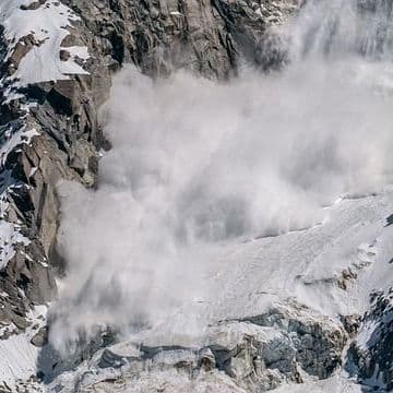
Moment Glacier Ice Breaks Off and Triggers Deadly Landslide in Nepal
At least a dozen hydroelectric projects were damaged, cutting one-tenth of Nepal’s power supply as rescuers searched flooded valleys.
- On August 28, 2026, a massive glacier and rock collapse near Nepal's Langtang Lirung peak triggered devastating flash floods. Surging water and debris swept through the Bhoti Koshi-Trishuli corridor, destroying roads, bridges, and infrastructure.
- Rising temperatures are accelerating ice melt and thawing permafrost across the Himalayan region, weakening steep mountain slopes. Glaciers diminish and lose frozen material that binds rock, increasingly destabilizing peaks above vulnerable downstream communities.
- Drone footage accidentally captured the collapse, providing researchers rare visual evidence of the disaster's opening moments. Unlike Switzerland, which monitors 1,400 glaciers with extensive instrument networks, Nepal lacks sufficient monitoring to predict these unpredictable mountain events.
- Destruction of bridges and roads has complicated rescue operations in isolated mountain locations. At least a dozen hydro-electric schemes were damaged or destroyed, effectively shutting off one-tenth of Nepal's national power supply.
- Reconstruction requires radically different thinking, as roads and homes must be made more resilient to a changing climate. Each collapse alters the landscape, leaving loose sediment poised for the next storm and complicating the future of mountain communities.
Insights by Ground AI
11 Articles
11 Articles


The disaster on the Nepal-Tibet border, which claimed hundreds of lives, was caused by a glacial collapse linked to global warming. According to data from the US Geological Survey, the massive glacial collapse, which triggered a magnitude 5.2 seismic tremor, created a 9-meter-high wall of water in the region.
·Istanbul, Türkiye
Read Full Article
Coverage Details
Total News Sources11
Leaning Left3Leaning Right1Center4Last UpdatedBias Distribution50% Center
Bias Distribution
- 50% of the sources are Center
50% Center
L 38%
C 50%
12%


Factuality
To view factuality data please Upgrade to Premium