Published • loading... • Updated
What Can We Expect From El Niño? Scientists Say Brace for the Worst.
The World Meteorological Organization says the event could drive above-average temperatures and shift rainfall patterns worldwide.
- September sea surface temperatures in the Niño3.4 Pacific region reached an all-time high of 29.70°C, the European Union's Copernicus Climate Change Service reported, while global average sea surface temperatures also hit a September record of 21.05°C.
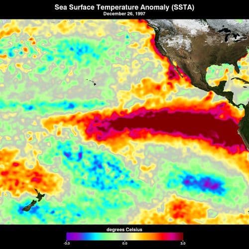
- El Niño is a natural climate cycle that warms tropical Pacific temperatures, typically recurring every two to seven years, and the current event is an 'exceptionally strong El Niño' that has not yet peaked, Copernicus stated.
- On Friday, Japan's weather agency declared this El Niño the 'strongest intensity on record' with temperatures 4°C above normal, although Copernicus maintained it 'cannot yet say that the current El Niño is the strongest ever recorded.'
- Widespread drought and flood risks are expected, the World Meteorological Organization warned, as the event shifts rainfall patterns, while the UN Development Programme warned of a 'perfect storm' potentially pushing millions into poverty.
- Copernicus director Carlo Buontempo warned that the new run of months above 1.5°C is likely to last into 2027, and experts have warned this El Niño could push global temperatures to a new record in 2027.
Insights by Ground AI
188 Articles
188 Articles


In the middle of the ocean, a huge heat bubble builds up. Measurement stations record unprecedented values, while the global weather patterns are shaken.
·Munich, Germany
Read Full Article
Uganda: Where Are the El Niño Rains? Meteorologists Explain Delayed Onset
[Independent (Kampala)] The expected El Niño rains have been slow to establish, with September recording below-average rainfall in parts of the country and limited rainy days that did little to support agricultural activities, according to a senior meteorologist.
·Washington, United States
Read Full Article

Winter is also getting closer and closer in the north. This year, a climate phenomenon could play an important role in this process.
·Syke, Germany
Read Full ArticleCoverage Details
Total News Sources188
Leaning Left16Leaning Right29Center29Last UpdatedBias Distribution39% Center, 39% Right
Bias Distribution
- 39% of the sources are Center, 39% of the sources lean Right
39% Right
L 22%
C 39%
R 39%


Factuality
To view factuality data please Upgrade to Premium