Published • loading... • Updated
Met Office Issues Snow Verdict as 'Polar Vortex' Could Bring Colder Weather to Essex
The Met Office says a weaker polar vortex could disrupt the jet stream and raise the chance of wintry showers, ice or snow, forecasters said.
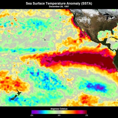
- The Met Office warned that the stratospheric polar vortex is weakening at the earliest date in at least 75 years, a highly unusual event potentially linked to the record-breaking climate phenomenon currently developing in the Pacific.
- Strong winds 15-50km above the Arctic trap cold air during winter, but when these winds weaken, the jet stream can shift, allowing freezing Arctic air to move southwards towards Europe.
- Jeff Knight, lead climate scientist from the Met Office, told the BBC: "It would appear to be the earliest on record looking back over the 75 years we've been observing … with most experts agreeing this is a very unusual event."
- Dr Matthew Patterson, a climate scientist at the University of St Andrews, said the event "changes the odds" to make colder weather more likely, though wintry showers and ice may reach Essex in the coming weeks.
- Professor Amanda Maycock, a climate scientist at the University of Leeds, warned long-term forecasts show "a very high chance of one of these events happening again later on in the winter," potentially prolonging drought conditions.
Insights by Ground AI
12 Articles
12 Articles


 Thurrock Gazette
+4 Reposted by 4 other sources


Met Office issues snow verdict as 'polar vortex' could bring colder weather to Essex
Met Office experts monitor a potential unusually early sudden stratospheric warming event, which could bring colder weather, ice or snow to Essex this winter.
·Essex, United Kingdom
Read Full Article
The polar vortex is making headlines again. Are we really in for snow?
Something unusual is happening high above the Arctic, and it’s already prompted talk of another Beast from the East. Weather expert Gareth Butterfield explains why forecasters are watching the polar vortex and what it might mean for Britain
·London, United Kingdom
Read Full Article
 The Independent
Reposted by  The Independent (US)
Will El Nino and the polar vortex mean more snow for UK this winter?
The polar vortex could hit earlier than expected according to forecasters
·London, United Kingdom
Read Full ArticleCoverage Details
Total News Sources12
Leaning Left3Leaning Right1Center7Last UpdatedBias Distribution64% Center
Bias Distribution
- 64% of the sources are Center
64% Center
L 27%
C 64%


Factuality
To view factuality data please Upgrade to Premium