Published • loading... • Updated
Canada Could Be in for a Dramatic Weather Shift After Historic Polar Vortex Reversal
The rare reversal could reshape the jet stream and open the door to colder air later this month, meteorologists said.
- On November 10, 2026, the stratospheric polar vortex over the Arctic reversed direction, slowing to approximately-0.1 metres per second. This unprecedented early reversal marks a historic atmospheric departure occurring roughly 30 kilometres above the North Pole.
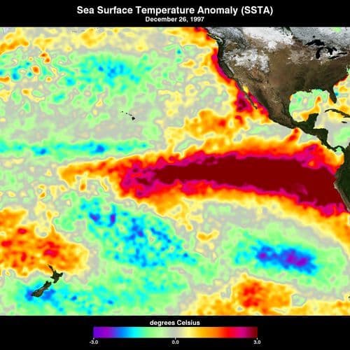
- Global News meteorologist Anthony Farnell noted this split is particularly unusual given the record-breaking El Niño, where Pacific water temperatures hit 3.5°C above average. These competing atmospheric forces create significant difficulty for forecasting Canada's winter.
- While the reversal is expected to be short-lived, with winds recovering to 25 metres per second later this month, the disruption could eventually allow cold Arctic air to push south into North America. However, the coldest air currently remains over Siberia.
- Forecast models suggest a potential transition of the EPO into negative territory, which could encourage higher pressure near Alaska and create a pathway for colder air. Meteorologists are monitoring the final 10 days of November for pattern shifts.
- The Weather Network will release its updated winter forecast on November 25, offering Canadians clarity as early December approaches. Experts will watch for persistent blocking patterns to determine if this atmospheric disturbance significantly alters the season's outlook.
Insights by Ground AI
12 Articles
12 Articles

'This Is an Unprecedented Situation' as Record-Early Polar Vortex Reversal Raises UK Snow Questions
Weather models indicate an unusually early reversal of Arctic polar vortex winds, but experts caution that the event does not guarantee significant UK snowfall this winter.
·United Kingdom
Read Full Article


The air circulation over the North Pole has temporarily come to a halt – as early in the season as never before. How it happened and whether it means something for the winter.
·Munich, Germany
Read Full Article
The polar vortex "broken, in November 2026, earlier than at any other time in the history of the measurements

The polar vortex, this huge cold air whirlwind located at the North Pole, was reversed this week: should we expect cold temperatures this winter?
·Montreal, Canada
Read Full ArticleCoverage Details
Total News Sources12
Leaning Left5Leaning Right0Center1Last UpdatedBias Distribution83% Left
Bias Distribution
- 83% of the sources lean Left
83% Left
L 83%
C 17%


Factuality
To view factuality data please Upgrade to Premium